 |
| Looking out at the Eastern Sierras from Hilltop Hot Springs |
A large chamber of magma churns, aches and pushes at the earths surface. Only a small amount of lava flows, until a series of earthquakes shakes the ground, then silence...BOOM! A giant explosion occurs blowing the top of the magma chamber and throwing 150 cubic miles of ash and rock[1] into the air which spreads as far away Kansas[2]. Over time a new roof forms, but at a point ~1.2 miles below the old roof, forming a depression 9 miles wide by 18 miles long called the Long Valley Caldera. This dramatic eruption which was 500 times larger than Mt. St. Helens (only 0.3 cubic miles of material[3]) and more than half as large as the last major Yellowstone eruption (240 cubic miles of material[4]) occurred approximately 760,000 years ago. Since then the area has remained volcanically active with eruptions of nearby mountains and the creation of hot springs. The springs, in particular Casa Diablo, were used by the Paiute Indians[5], then by stage coach travelers from 1878 to 1881[6] and finally by motorist once highway 395 was created. Today Casa Diablo is a power plant station and is unusable by the public, but there are more than a half dozen publicly accessible springs located nearby.
The main cluster of hot springs is located near the center of the caldera and southeast of the resurgent dome in an area named Whitmore Tubs. The area contains the following springs:
- Wild Willies a.k.a. Crowley Hot Springs
- Hilltop Tub
- The Rock Tub
- Shephard's Tub
- Crab Cooker
In addition there is one other spring at Little Hot Creek just outside the area. I wasn't able to make it to Shephard's or Crab Cooker, but was able to make it to the rest.
This spring is the largest and most popular. The parking area is large but was filled with many people camping both in tents and trailers when I visited. From the parking lot is a short 1/4 mile walk on a nice boardwalk through alkali meadows installed by the BLM in 1998[7]. First you'll pass by a small heart shaped tub which can hold around 8-10 people and is the hotter of the two. A few paces down the trail you'll come to the large tub which is partially gravel and partially concrete and can hold 20+ people. The larger tub has a nice temperature gradient, with it being very hot near the inlet and a nice comfortable temperature near the outlet. Unfortunately I forgot to bring my thermometer on this trip and so wasn't able to get readings, but I would guess that the upper pool is consistently over 100F and the lower pool anywhere from 95F to 105F depending on where you are sitting.
I visited the spring with Tram and a friend on a Friday evening around sunset in mid-summer and there were 20+ people between the two pools with everyone wearing a bathing suit. Many of us were drinking a beer and after a 15 minutes or so we'd struck up a conversation with strangers. I think soaking in hot water while watching the sun set in the Sierra's can even put the biggest grouch in a sociable mood. We picked up some critical intel on nearby springs during our conversations as well as recommendations for good hikes in the area.
A third of a mile down Benton Crossing Rd. from the turnoff for Wild Willies is the turnoff for Hilltop Hot Spring, perhaps the most scenic of all the Whitmore tubs. The walk from the parking area is 1/4 mile on a nice gravel path and board walk that ends on a large white silica sinter deposit. After walking across the clearing, reminiscent of a moonscape, you come to a concrete and rock tub surrounded by turf mats. The mats may seem crude, but in reality are functional, saving your feet from the sharp pebbles while entering and exiting the tub. As you lower yourself in the tub, only large enough to fit 6-8 people, you see mountains to your east and west with the enormous Long Valley extending for what seems like an eternity to the north and south. The hill the spring sits atop is in reality only a small rise, but it is enough to give you a commanding view of your surroundings.
I visited this spring in the morning around eight, too late for sunrise, but early enough to be the second car in the parking lot. Fresh cow patties dotted the grass and portions of the path on my walk to the tub. The chill of the morning air brought goose bumps to my skin. As I crested the hill I could see that no one was in the tub and for the moment it would be just the nearby cow's and I to share a pleasant Eastern Sierra morning. I dipped my hand into the water, checking the temperature, it was very hot. The previous bather had left the ball valve open almost the whole way, filling the tub with 105F+ degree spring water. There is no cool water nearby to temper the heat with so the only option is to turn off the valve and sit in the water for short duration while waiting for it to cool.
The easiest to find of all the springs has to be The Rock Tub. Located just off Whitmore Tubs Rd. and much nearer to highway 395 you can drive right up to the tub. A smaller spring facing the eastern face of the sierras and only enough room for 4-8 people. In 2005 the BLM announced plans to restore the roads, dispersed camping sites and nearby Sage Grouse strutting grounds, called leks[8]. While visiting I saw signs of roads blocked by boulders, but the main gravel roads were fairly rutted out and the campsites didn't seem to have any real maintenance done to them.
Tucked away in a small valley down several dirt roads and located next to a stream is the excellent Little Hot Creek Hot Spring. It's a little more of an adventure to get to this secluded spring compared with the Whitmore Tubs, but it's absolutely worth it.
As you sink into the tub, formed of smooth concrete, you'll likely hear a dragonfly buzz past or maybe a grasshopper will flutter by. You may even see a Yellow-headed Blackbird in hot pursuit. The trickle of Little Hot Spring creek, just yards away, provides a relaxing audio bed to the song of summer in the High Sierras. After a few minutes, adjust the valve to let more spring water in, sit back and let the world melt away.
Wild Willies
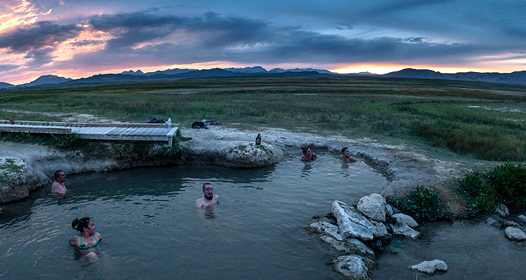 |
| The sun sets over Long Valley as bathers enjoy the main tub at Wild Willies. |
I visited the spring with Tram and a friend on a Friday evening around sunset in mid-summer and there were 20+ people between the two pools with everyone wearing a bathing suit. Many of us were drinking a beer and after a 15 minutes or so we'd struck up a conversation with strangers. I think soaking in hot water while watching the sun set in the Sierra's can even put the biggest grouch in a sociable mood. We picked up some critical intel on nearby springs during our conversations as well as recommendations for good hikes in the area.
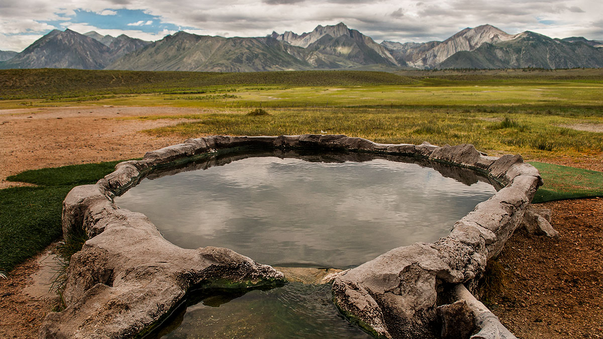
Hilltop Hot Spring
A third of a mile down Benton Crossing Rd. from the turnoff for Wild Willies is the turnoff for Hilltop Hot Spring, perhaps the most scenic of all the Whitmore tubs. The walk from the parking area is 1/4 mile on a nice gravel path and board walk that ends on a large white silica sinter deposit. After walking across the clearing, reminiscent of a moonscape, you come to a concrete and rock tub surrounded by turf mats. The mats may seem crude, but in reality are functional, saving your feet from the sharp pebbles while entering and exiting the tub. As you lower yourself in the tub, only large enough to fit 6-8 people, you see mountains to your east and west with the enormous Long Valley extending for what seems like an eternity to the north and south. The hill the spring sits atop is in reality only a small rise, but it is enough to give you a commanding view of your surroundings.
 |
| A boardwalk keeps vistors above the water soaked ground on the way to Hilltop Hot Spring (left); PVC piping and a valve allows control of the temperature to suit ones preference (right). |
I visited this spring in the morning around eight, too late for sunrise, but early enough to be the second car in the parking lot. Fresh cow patties dotted the grass and portions of the path on my walk to the tub. The chill of the morning air brought goose bumps to my skin. As I crested the hill I could see that no one was in the tub and for the moment it would be just the nearby cow's and I to share a pleasant Eastern Sierra morning. I dipped my hand into the water, checking the temperature, it was very hot. The previous bather had left the ball valve open almost the whole way, filling the tub with 105F+ degree spring water. There is no cool water nearby to temper the heat with so the only option is to turn off the valve and sit in the water for short duration while waiting for it to cool.
The Rock Tub
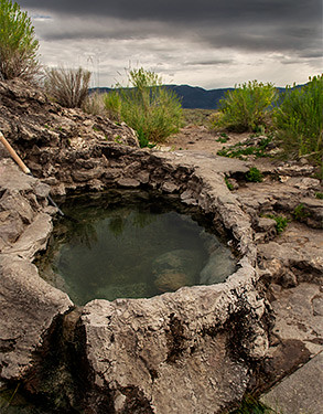 |
| The Rock Tub is a small tub built with rocks and concrete. |
Little Hot Creek Spring
Tucked away in a small valley down several dirt roads and located next to a stream is the excellent Little Hot Creek Hot Spring. It's a little more of an adventure to get to this secluded spring compared with the Whitmore Tubs, but it's absolutely worth it.
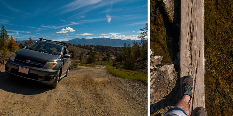 |
| Clearance is tight with some vehicles (left), and some balance is required while crossing Little Hot Creek (right). |
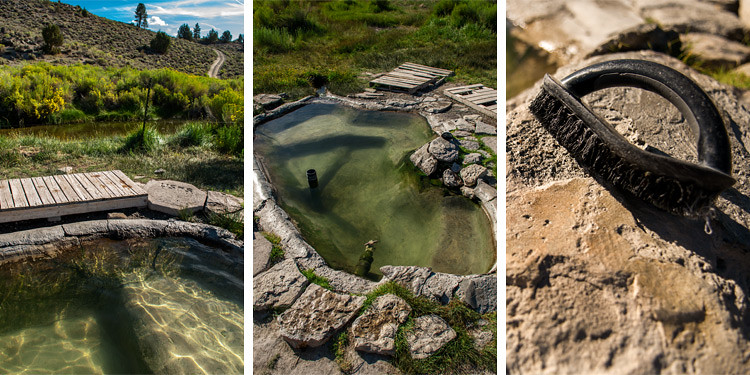 |
| View from the tub (left), Little Hot Creek has a nice concrete tub with inlet control and an overflow pipe (center), If you're gonna bathe then you need to put in some work scrubbing (right). |
Nearby Geological Features
If you stop by for a soak in Long Valley make sure not to miss some other nearby geological attractions. The caldera and the area surrounding it contain some unique natural features, some more accessible than others, but all are worth a visit.
Hot Creek Geological Site

Mammoth creek flows out of Twin Lakes at a cool 50F, some 11 miles later warmer waters from thermal springs enter the creek and its name changes to Hot Creek[9]. Hot Creek has been well known for generations as a place for great swimming and spectacular fishing. It was even a filming location for several movies in the 60's and 70's, among them True Grit.
While the gorge in particular has been popular for swimming in the past, it has had it's fair share of injuries and deaths, mostly due to users ignoring signs and fences and entering hot pools[10]. With a heavy increase in unpredictable thermal activity in 2006, swimming has been prohibited indefinitely. Discharges of boiling water can erupt to heights of six feet in the middle of the previously calm stream, raising temperatures from 86F to 199F in seconds. These discharges often hit fish, causing them to cook instantly.
Despite the ban on swimming and danger presented by the thermal activity the Hot Creek Geological Site is a wonderful place to visit. After a short hike down a paved trail you'll find yourself set in a rugged brown gorge, with lush green aquatic grasses running along the stream bed and brilliant cerulean colored pools lining the opposing bank. And if you've brought your fly rod along, after a short hike upstream or down, you may find yourself hooked into a beautiful trout.
Horseshoe Lake
In 1990 scientist noticed that tree's were dying on the north side of Horseshoe Lake. At first the cause was though to be drought or insect infestations, but in 1994 the culprit was found to be abnormally high levels of CO2 in the soil[11]. Typical levels of soil CO2 are around 1% or less; levels in the tree-kill area were found to be 20% to 90%! The tree-kill area rapidly grew to around 120 acres, but by 1996 the CO2 discharge rate stabilized and the growth of the tree-kill area slowed[12].
The reason for the CO2 discharge is thought to associated with a series of earthquakes in 1989 due to a magma chamber moving closer to the surface. These earthquakes likely caused fissures which allowed the CO2 to escape from the chamber where it had been accumulating. There are several other tree-kill areas around Mammoth Mountain, which test have shown are caused by the same chemically identical CO2 that is present at Horseshoe Lake. This points to the being a large chamber of gas in the mountain.
Pockets of CO2 buildup, called Mazuku, are present around the lake a nearby Mammoth Mountain. Numerous signs are present around the lake which warn visitors from sitting on the ground and luckily most have heeded this advice. Still there have been several reports of asphyxiation symptoms, such as a U.S. Forest Ranger in 1990[13], and even the death of cross country skier in 1998[14]. In addition, three ski patrol members were killed on nearby Mammoth Mountain after falling into a snow pit while fencing off an active fumarole.
Devil's Postpile
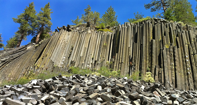 |
| The 60 foot high wall of columnar basalt at Devils Postpile National Monument. Original photo by Peretz Partensky. |
To the west of Mammoth Mountain sits an excellent example of columnar basalt called Devils Postpile. While columnar basalt is not especially rare, the size and number of columns on display here put's it as one of the best sites in the world. Columnar basalt is formed due to stresses that occur when lava cools[15]. 80,000 to 100,000 years ago a lave lake formed in this area, reaching depths of 400 feet in places, and as it cooled the joints in the basalt formed creating long symmetrical cracks. The formation remained hidden for thousands of years until finally, water and glaciers began to erode portions away[16]. The feature was much larger thousands of years ago, but as is evident in the large field of broken columns at the base, erosion has taken its toll.
Crowley Lake Columns
This relatively newly discovered and hidden geological feature has been a mystery for over 70 years. Shortly after Crowley Lake was formed, by the construction of Long Valley Dam in 1941, strange columns began to appear along the eastern shore[17]. The clusters of columns, estimated to be around 5,000 in total, have the appearance of a Moorish Temple. Research conducted by UC Berkeley has given rise to the theory that they were formed during the last explosion of the Long Valley Caldera. As cold snow melt seeped into the hot tuff deposit it boiled, creating convection columns. Research is still ongoing to better understand how these unique features were formed.
Finally to help with location's I've put together a map of all the springs and other attractions:
Sources:
[1] http://volcanoes.usgs.gov/volcanoes/long_valley/field_guides_long_valley.html
[2] http://www.indiana.edu/~sierra/papers/2013/yohler.html
[3] http://pubs.usgs.gov/gip/msh/comparisons.html
[4] http://volcanoes.usgs.gov/volcanoes/yellowstone/yellowstone_geo_hist_88.html
[5] http://en.openei.org/wiki/Long_Valley_Caldera_Geothermal_Area#cite_ref-Long_Valley_Caldera_Field_Trip_Log_17-1
[6] http://noehill.com/mono/poi_casa_diablo.asp
[7] http://www.blm.gov/ca/st/en/fo/bishop/restoration/rp_wildwillies.html
[8] http://www.blm.gov/ca/pdfs/bishop_pdfs/eadocs/WhitmoreTubs_Leks_Project.pdf
[9] https://pubs.usgs.gov/fs/2007/3045/fs2007-3045.pdf
[10] https://volcanoes.usgs.gov/volcanoes/long_valley/field_guides_hot_creek.html
[11] https://pubs.usgs.gov/fs/fs172-96/
[12] https://pubs.usgs.gov/dds/dds-81/Intro/MonitoringData/CO2/CO2.html
[13] https://pubs.usgs.gov/wri/wri98-4217/
[14] http://articles.latimes.com/2006/apr/07/local/me-mammoth7/2
[15] http://volcano.oregonstate.edu/columnar-jointing
[16] https://www.nps.gov/depo/learn/nature/geology.htm
[17] http://www.latimes.com/science/la-me-adv-volcanic-columns-mystery-20151115-story.html


No comments :
Post a Comment